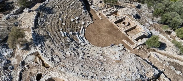
Hydas Ancient City: The Ruins Above Selimiye Bay


 React
Behind the waterfront restaurants of Selimiye, where fishing boats bob a few metres from the tables, a rocky hill rises above the village. On its crest, broken walls of grey stone trace the outline of a fortress, and from the top the whole bay opens up beneath you: the curve of the village, the tiny islet with its own ruined castle, the fish farms out in the Hisarönü Gulf and the ridges of the peninsula fading into the distance.
These are the remains of ancient Hydas, one of the small Carian towns of the Bozburun peninsula. There is no ticket office, no museum and usually nobody else on the hill. What you get is a short, steep walk, a sense of history and one of the best views on the peninsula, followed, ideally, by a long lunch by the water.
Quick facts
| Location | The hills above Selimiye, Bozburun peninsula, about 43 km from Marmaris by road |
| Entry | Free; open site with no ticket office or fixed hours |
| Bus Marmaris-Selimiye | Route 10-11: 158 TL (~$3.20) one way, 316 TL (~$6.40) return |
| Drive from Marmaris | About 50 minutes on a winding road |
| Time needed | Allow 1-2 hours for the walk up, time at the top and the return |
| Difficulty | Short but steep and stony; no facilities or shade |
| Best time | Early morning or late afternoon; spring and autumn |
Where it is
The village of Selimiye sits on a sheltered bay on the eastern side of the Bozburun peninsula, facing the Hisarönü Gulf. It is part of Marmaris district in Muğla province. The ancient settlement occupied the high ground around the bay: Hellenistic city walls run along the hills on the southeast side, while the main fortress ruins crown the highest hill directly above the village. Two more fortifications associated with Hydas stand nearby, on Sarıkaya Hill and at Asarkale near Kızılköy.
How to get there from Marmaris
By bus
MUTTAŞ route 10-11 runs from Marmaris to Bozburun via Hisarönü, Orhaniye (Kızkumu), Turgut and Selimiye. Pay on board with a Muğla Kart or a contactless bank card.
| Departures from Marmaris (and from Bozburun) | |
|---|---|
| Weekdays | 07:00, 08:30, 10:30, 12:30, 14:30, 16:30, 18:30 |
| Saturday and Sunday | 08:30, 10:30, 12:30, 15:30, 18:30 |
| From Marmaris to | One way | Return | Approx. USD |
|---|---|---|---|
| Orhaniye / Kızkumu | 103 TL | 206 TL | $2.10 / $4.15 |
| Turgut | 112 TL | 224 TL | $2.25 / $4.50 |
| Selimiye | 158 TL | 316 TL | $3.20 / $6.40 |
These are full adult fares with an electronic card. Buses back to Marmaris pass through Selimiye a little after they leave Bozburun, so ask the driver or check the MUTTAŞ timetable for the time at the Selimiye stop. Timetables change during the year.
By car
Follow the Datça road out of Marmaris, turn off at Hisarönü towards Bozburun and continue via Orhaniye and Turgut. The drive takes about 50 minutes, with plenty of bends and climbs. Park in the village, since spaces near the start of the path are limited, and walk up from there.
By boat
If you are on a gulet or yacht, Selimiye is a popular overnight stop, and the ruins make an easy evening or early-morning walk from the harbour. See our guide to Marmaris boat trips for choosing a boat.
The walk up
The climb starts with a short walk from the waterfront into the back streets of the village, then continues on a stony path up the hillside. It is not long, but it is steep in places, with loose stones underfoot and no shade at all. Take your time, use the goat tracks with care and turn around often: the view over the bay improves with every few metres of height.
There are no waymarks worth relying on and no barriers near the drops. Download an offline map before you start, wear proper shoes and keep children close to you near the walls.
In July and August, go early in the morning or about two hours before sunset. The hill faces the full force of the midday sun.
A short history
In antiquity, Hydas was one of the small towns of the Carian Chersonese, the old name for the rugged peninsula south of Marmaris. Finds from the Archaic period show that people were living here long before the fortifications you see today. The Roman writer Pliny the Elder lists the town in his Natural History, one of the few ancient texts to mention it.
The town’s strength was its position: a sheltered bay, good farmland behind it and high ground from which to watch the approaches to the Hisarönü Gulf. In the Hellenistic period, when much of this peninsula was controlled by Rhodes, Hydas was walled; those Hellenistic walls still run along the hills southeast of the bay. In the Middle Ages, the hilltop was fortified again, and the main castle ruins are generally dated to the Byzantine period, around the 13th century.
The village later took the name Losta, and then Selimiye, after the Ottoman sultan Selim I.
What you will see
- The hilltop fortress: sections of curtain wall built of local limestone, with the bases of towers at the corners and gaps. The masonry is practical rather than decorative, made to withstand attack, not to impress.
- Cisterns: rock-cut and stone-lined cisterns, a reminder of how precious water was on this dry peninsula.
- Terraces: stone terraces on the slopes, used for buildings, storage and farming.
- The Hellenistic walls: on the southeast hills of the bay, older and more finely built than the medieval castle.
- The islet castle: the small ruined fortification on the islet in the middle of Selimiye Bay, best seen (and photographed) from the hill.
- The view: the whole bay, the gulf and the peninsula ridges. For most visitors, this is the real reward.
Keep your expectations realistic. This is a modest site with no reconstructed buildings or signs, and its charm lies in the setting and the quiet.
Practical tips
- Entry is free, and there is no ticket office or gate.
- There are no toilets, shops or water on the hill. Use the village cafés before you set off.
- Wear closed shoes with a good grip; sandals are a bad idea on the loose stones.
- Carry water, a hat and sunscreen, even for a short visit.
- Do not climb on the walls or move stones.
- Take all litter back down with you.
- Flying a drone over archaeological sites in Turkey requires official permission.
- The wind can be strong on the summit; steady your camera or tripod.
Photography tips
The strongest compositions use a broken corner of the wall in the foreground with the bay and the islet behind. Early morning brings soft light and calm water; in the late afternoon, side light picks out the texture of the stone, and the sun sets behind the hills on the far side of the bay. A wide lens takes in the full panorama, and a person on the wall’s edge (at a safe distance from the drop) gives a sense of scale.
After the walk: Selimiye
Coming down from the hill, Selimiye’s waterfront is the obvious reward. Restaurants line the bay with tables almost in the sea, and the village is known for long, slow fish lunches and dinners. As a price guide for 2026, at Bahtiyar Restaurant on the waterfront breakfast costs around 500 TL ($10) per person and cold meze around 300 TL ($6) each.
Day boats also leave Selimiye for the coves around the peninsula, including Kamelya Island with the ruins of its Byzantine monastery. Shared full-day trips cost around 1,500-2,000 TL ($30-40) per person, depending on the route, lunch and drinks.
For staying overnight, see our Bozburun peninsula guide and where to stay in Marmaris.
Combine it with
- Kızkumu in Orhaniye: the sandbar where you can walk out into the sea, on the same bus route. See our Marmaris beaches guide.
- Turgut waterfall: small falls and natural pools just before Selimiye, at their best in spring and early summer.
- Bozburun: the boat-building harbour at the end of the bus route.
- Bayır: a village with a huge, ancient plane tree in its square, on the road to Söğüt.
- The sanctuary of Hemithea at Kastabos: the remains of a Carian healing sanctuary in the hills above Hisarönü, near ancient Bybassos.
- Other ancient sites: the harbour fortress of Loryma at the tip of the peninsula, Amos above Turunç, Knidos and the rock tombs of Kaunos.
A simple day plan
- 08:30: bus from Marmaris on route 10-11.
- 09:45: arrive in Selimiye, have a coffee by the water.
- 10:15: walk up to the ruins before the heat builds.
- 12:30: swim from one of the waterfront platforms, then a long lunch.
- Afternoon: a stop at Kızkumu or Turgut waterfall on the way back, or a direct bus to Marmaris.
Frequently asked questions
Is there an entrance fee for Hydas?
No. The ruins are an open site with no ticket office or fixed opening hours.
How long does the walk take?
The climb from the village is short but steep. Allow one to two hours in total, including time at the top and the walk back down.
Can I get to Hydas by bus from Marmaris?
Yes. Route 10-11 to Bozburun stops in Selimiye; the fare is 158 TL (about $3.20) one way. The ruins are a walk from the village.
Is it suitable for children?
For older children who are steady on their feet, yes. The path is stony, and there are unprotected drops near the walls, so keep younger children close.
What is the best time to visit?
Spring and autumn, early in the morning or late in the afternoon. Avoid midday in summer.
Where can I eat nearby?
The waterfront restaurants of Selimiye are just below the hill and are one of the main reasons to make the trip.
Plan more days out
For more ideas, see things to do in Marmaris and the Marmaris Travel Guide.