Loryma Ancient City
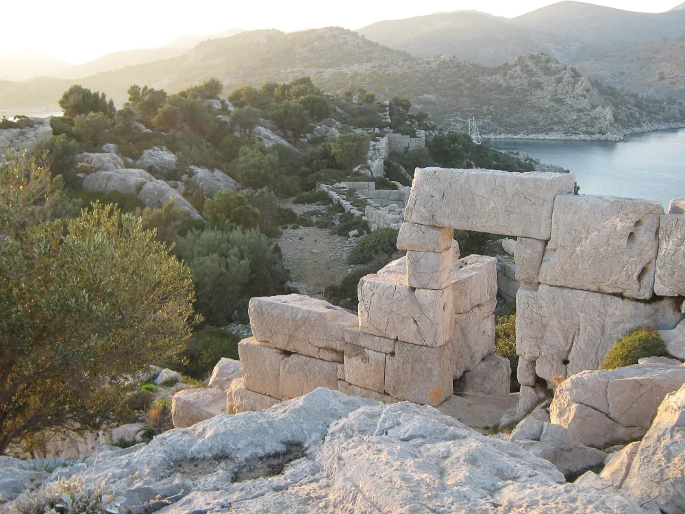
Loryma greets you with wind, stone, and shimmering sea. It sits at the mouth of Bozukkale Bay near Marmaris. Ancient walls crown a headland above glass like water. Boats drift below while goats climb the scented slopes. There is silence, except for the gulls and cicadas. Time seems folded into the limestone and thyme. Yet the site feels welcoming and surprisingly accessible. You can hike, sail, and linger with rewarding views. History here arrives through landscape and small details. Every block hints at garrisons, traders, and sailors. Your reward is calm, color, and deep Aegean clarity. Loryma makes a perfect slow adventure from Marmaris. The approach itself becomes part of the experience. You arrive slowly, then everything clicks into place. This corner of the Turkish Aegean feels remarkably unspoiled.
Where is it and how to get there?
Loryma stands on the Bozburun Peninsula, southwest of Marmaris, in Turkey. It overlooks Bozukkale Bay, a natural harbor with two headlands. Most visitors arrive by boat from Marmaris, Selimiye, or Bozburun. Daily gulet trips often include a swimming stop here. Sailors anchor in the sheltered bay beside simple jetties. You can also reach the site by a rough road. Drive toward Taslica village, then follow the coastal track. A final hike leads up to the long fortress ridge. Wear sturdy shoes and carry water in summer. The sun is strong and shade remains limited. Navigation apps help, but local advice is invaluable. Ask in Selimiye or Bozburun before you set off. Taxi boats can be arranged through local pensions. Sea conditions matter, so check forecasts before committing.
Brief History
Loryma belonged to ancient Caria and the Rhodian mainland possessions. The bay formed a strategic naval station for coastal control. Hellenistic commanders valued its deep, protected waters. Fleets gathered here during campaigns along the Aegean. The Turkish name Bozukkale means broken castle, echoing ruined walls. Rhodian influence shaped the fortifications and regional trade. Later Roman and Byzantine periods reused the commanding site. Watchposts guarded approaches to the harbor and channels. Medieval sailors still recognized the bay’s secure embrace. Over time, garrisons left and stones slipped toward the sea. Today, the ruins survive as open air testimony. You walk through layers shaped by war, trade, and weather. Inscriptions once recorded dedications to protective deities. Pieces now lie scattered among thyme and prickly oak. Mariners knew the bay as a haven during sudden storms.
Architecture and Artistic Features
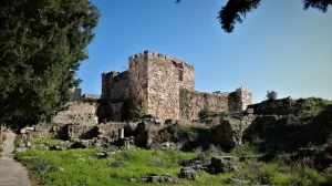
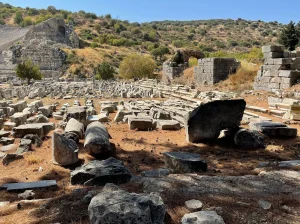
The fortress runs along a ridge above the bay. Curtain walls trace the slope with deliberate, defensive geometry. Large ashlar blocks fit with careful joints and minimal mortar. Towers project at intervals to cover vulnerable approaches. Gateways survive with thresholds smoothed by many feet. Stairways climb to parapets with sweeping harbor views. Within the circuit, you notice cistern mouths and house platforms. Rock cut details reveal measured planning and resourceful engineering. A shoreline mole and quay stones appear at low water. Chapel traces suggest later piety among the ruins. The whole plan answers wind, current, and enemy angle. Function meets landscape, and the result feels timeless. Look for masons’ marks on some squared blocks. Drain channels guide winter rain toward buried cisterns. The engineering feels economical and confident throughout.
Visitor Information
A few practical notes will improve your visit to Loryma.
- There is no ticket office or formal gate.
- Access is free, but you must respect the site.
- Best seasons are spring and autumn for mild weather.
- Summer heat is intense and shade is limited.
- Wear sturdy shoes with grip for uneven stones.
- Carry plenty of water and light snacks.
- Boat access is easiest for most travelers.
- Hikers should start early and follow marked paths.
- Mobile signal can be weak near the bay.
- Basic piers host a few seasonal eateries in summer.
- Pack out all litter to protect this fragile place.
- Guides in Marmaris or Bozburun offer informed walks.
- Swimming stops are possible in clear, inviting water.
- Respect wildlife and avoid feeding goats near paths.
Photo Spots and Tips
Climb the main wall for the classic bay panorama. Turn north to frame the serrated ridge and channels. Early morning brings pearly water and delicate textures. Late afternoon gives warm color and long shadows. Use a wide lens to embrace walls and bay. Switch to a short telephoto for layered headlands. Watch your footing on loose gravel near edges. Include a boat to suggest scale and purpose. Clouds add mood on unsettled days. Always respect any restrictions on drones or climbing. A polarizer helps cut glare on the water. Wipe lenses often in salty breeze conditions.
Other Nearby Places to Visit
Selimiye offers a pretty harbor, calm water, and seafood. Bozburun charms with boatyards and quiet waterfront cafes. Amos lies near Turunc with a small theater and views. Marmaris Castle presents a compact museum and ramparts. Orhaniye features the shallow sandbar known as Kizkumu. Serce Bay shelters clear water and a remote feel. Turgut Waterfall cools the air with shaded pools. Datca Peninsula leads to Knidos with grand ruins. Each stop pairs well with a Loryma excursion. Plan more than one day if you love slow travel. Seljuk and Ottoman traces appear in village mosques and cemeteries. Roads are narrow, so drive patiently and attentively.
Loryma rewards curiosity with space, light, and layered stories. Come for the ruins and stay for the sea air. If you visit Marmaris, include Loryma on your route. You will leave calmer and richer with perspective. For more trip ideas, read our Marmaris Places to Visit guide. Share your impressions to inspire other mindful travelers.